
Darkstore location & delivery areas mapping for food delivery leaders
Trusted by Fortune 500.
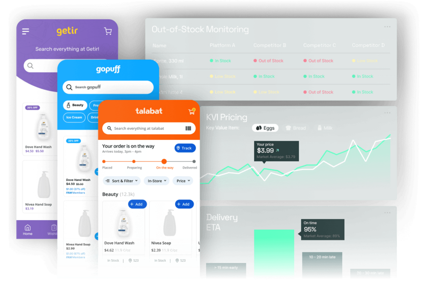
Get real-time data from all quick commerce platforms.
Your team operates with critical blind spots across the physical grid
Relying on lagging market share reports leaves your operations teams blind to competitor network expansion. When you cannot see where rival dark stores are opening or extending their radius, you forfeit the first-mover advantage in high-density neighborhoods.

What a darkstore location mapping record looks like
This record details exact geographic coordinates, estimated delivery radii, and public operating hours for a specific competitor node. Strategy teams plug these points directly into mapping tools to visualize exact coverage overlaps and white spaces in real time.
| Competitor Node | Coordinates | Delivery Radius | Operating Hours | Status | Last Detected |
|---|---|---|---|---|---|
| Deliveroo Hop - Acton | 51.5081, -0.2734 | 2.2 km | 08:00 - 00:00 | New Node | today 09:14 |
| Flink - Berlin Mitte | 52.5200, 13.4049 | 1.8 km | 07:30 - 23:00 | Active | today 11:42 |
| Gopuff - Battersea | 51.4668, -0.1631 | 2.5 km | 24/7 | Active | yesterday |
| Zapp - Fulham | 51.4800, -0.1900 | 2.0 km | 24/7 | Closing | 2 days ago |
| Wolt Market - Kallio | 60.1841, 24.9493 | 3.0 km | 08:00 - 22:00 | Relocating | today 14:05 |
Your team commands a complete view of the competitive physical grid
We continuously scan publicly available location signals to map the exact footprints of competing quick commerce networks. Your operations leaders receive accurate facility counts and delivery boundaries updated at the speed of the market.
Digital grocery runs on price, availability & visibility

Out of stock = leaving margin on the table
Product matching makes or breaks your data
Top products must be available at 7 PM
Top products matter across every grocery platform
Deploy capital and capture demand with absolute geographic precision
Mapping competitor delivery zones transforms real estate and operations planning from reactive defense into proactive market capture. Leaders optimize network topology to dominate high-value neighborhoods while avoiding unprofitable turf wars.
From scattered public signals to a unified geographic map in three stages
Our pipeline continuously monitors public location indicators to plot dark store networks accurately. The resulting spatial intelligence flows seamlessly into your existing geographic information systems.
Extract
Geocode
Deliver
Questions we get from strategy leaders like you
Evaluating spatial data providers requires absolute clarity on accuracy, freshness, and legal compliance.
Start mapping your true competitive landscape today
Request a sample location dataset tailored to your most critical expansion market. Our intelligence team will walk you through the coverage overlap analysis with no obligation to commit.
- A dedicated data expert assigned to your case
- No obligation, free consultation
- Full support from scoping to delivery
Need an NDA first? Just mention it in the form - we're happy to sign.